Rieti Rest day
![](https://blogger.googleusercontent.com/img/b/R29vZ2xl/AVvXsEioepqpAon_KteLnhtTgkKzqH6DhkvwK0XigSwcQbMaDPoi_PF-14BkX6Tt4yRm8LlAlAZt25y7TC0XIzSIYiyGCYvhHMptA5Ico-eCA7HtsxtKlDBctOn6e2MkMTJcjhiM8kSc/s320/waterfall.jpg)
![](https://blogger.googleusercontent.com/img/b/R29vZ2xl/AVvXsEhURByVjlX6OZhKywtofkJB9-00beaOgi_tCsAxpElmi2V_XhLuOrSuVm-P-uvh6V-dQ7negG5VPEs6QXj-30hE4WL3rM1aDUa3BnZwXUsyMz-HAk_nS36Vd3TdZaBX2n1yqVEX/s320/waterfall2.jpg)
![](https://blogger.googleusercontent.com/img/b/R29vZ2xl/AVvXsEgAHO-HzwIE0UnUdjWUOO4cv9kPHc0DhUau8GxeeTNbZ5y4qDTa3DTMQqERgUIEioQuN49vJ6jwtAuSXBNM6_3hQWKEW_4wMq7NjiSv_AGf-m29fn3Yi-9aHI2C85e6ge35H-ix/s320/subterrain+rieti.jpg)
![](https://blogger.googleusercontent.com/img/b/R29vZ2xl/AVvXsEiPgwMiGT5AowD9J-4o0PTs7QeiH2oxA0K8GFf5RFS7e6JAaX06hq2fT8OzjvQu03cEFMhEER6guTcjDkWpocKevAAnV22o_ah5wRLui7v61K_P7XragXjkvJJ6z5gQ6zooAbHe/s320/top+section+roman+wall.jpg)
A couple of pics of the waterfall - largest in Europe, made by the Romans to drain the plateau and Riete surrounds.
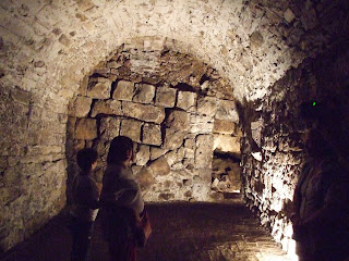
The old map of reiti shows a road running uphill from the bottom left. This is a Roman road and buildings are built up now around it (medieval). The other picture is taken from under a building, which is medieval and you can see the Roman road - the wall of it - visible in the arch. This is the top of the wall/road as a lot of rubbish has accumulated in 2000 years.
0 Comments:
Post a Comment
<< Home